How to Locate Last-Mile Interference

Hunting last-mile interference using manual triangulation
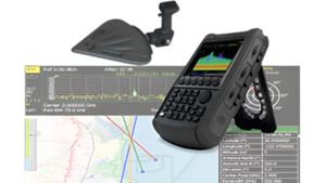
Determining the location of an unknown signal source requires advanced direction-finding (DF) techniques. When locating last-mile interference, manual signal triangulation is an effective DF method. The process focuses on a sequential measurement approach of signal reception, phase difference, angle calculation, line of bearing, and intersection point. Initially, the DF antenna and receiver gauge the signal reception, capturing the signal’s strength as the antenna sweeps manually through various orientations. The strongest signal direction indicates the peak power and helps determine the phase difference. Derive the angle calculation using the antenna’s alignment relative to the signal’s peak power, rotating the antenna and noting the direction of the strongest signal reception. Establish the signal’s azimuth by aligning the peak reception with a known reference point, typically true north.
Measuring the peak power, azimuth, and geographical position for manual signal triangulation requires a robust test system. The test system includes a single high-gain directional antenna, an RF receiver capable of discerning signal strength and phase, and a GPS device to provide precise location data. The operator moves to different locations, recording the azimuth and GPS coordinates at each point. Then the operator programmatically calculates the angle and combines it with the receiver’s geoposition to establish the line of bearing, which represents the projected path of the signal from the receiver back to its source. The intersection point of multiple mapped bearings pinpoints the signal source. This process integrates with a mapping system for a visual representation triangulating the unknown signal interference.

Last-mile interference-finding solution
See demo of last-mile interference-finding solution
This is a modal window.
Explore products in our last-mile interference solution
-

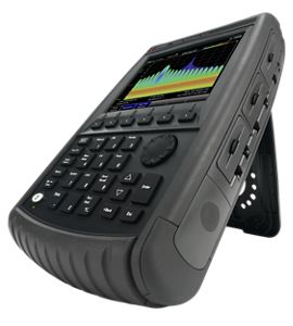
N9912C FieldFox Handheld RF Analyzer, up to 10 GHz

Discover resources and insights
Additional resources for locating last-mile interference
Related use cases

-
How to Monitor 5G Field Interference
Identifying in-band and out-of-band interference requires real-time spectrum analysis and signal-capture capabilities. Learn how to capture elusive, intermittent signals and interference using real-time spectrum analysis.
Learn more

-
How to Locate Interfering Signals with TDoA
Determining the location of unknown emitters requires advanced direction-finding techniques, such as triangulating the time delays between receiver pairs. Learn how to use time difference of arrival (TDoA) to calculate the source location of interfering signals.
Learn more
-
How to Characterize 5G mmWave Air Interface
Characterizing 5G over-the-air performance requires an integrated, portable signal analyzer with a phased array antenna. Learn how to overcome key 5G network deployment challenges by characterizing millimeter-wave path loss and coverage.
Learn more

Get in touch with one of our experts
Need help finding the right solution for you?